Bedrock and Overburden Depth Mapping
The oldest and most reliable method for continuous bedrock mapping is through combined seismic methods data sets that are collected simultaneously.
Seismic methods are ideal for depth ranges from 5 meters to any depth.
Seismic methods are ideal for obtaining continuous Shear-wave (Vs) and Compressional-wave (Vp)
Data Collected from Surface
- Topography
- Fill versus native
- Saturated versus unsaturated
- Loose versus Dense
- Weathered versus unweathered
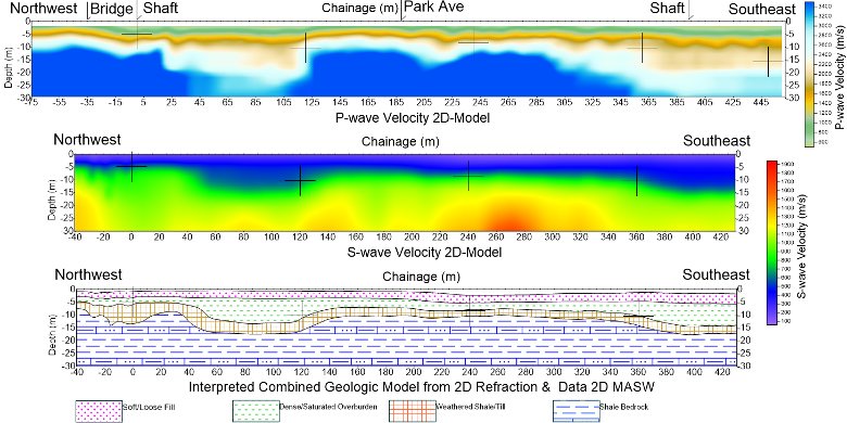
2D Profile with compressional wave velocities. Referred to as Refraction Tomography.

Assigning a geologic unit to each range of velocities.

Refraction Tomography and MASW Profile combine to generate a complete geologic interpretation.
Combining 2D Profiles

Many 2D profiles can be collected quickly to produce a 3D plan map of bedrock elevations

Data can be collected on land and water


When data can be collected along a drivable road then the sensors can be dragged and the seismic source is an elastic hammer: called a Land Streamer


This is a relatively short profile of under 500 meters collected in less than a day.

HVSR data used to calculate bedrock depth at specific locations using devices such as HVSR device, Tromino™ BLU or 3 component Smartsolo™ IGU-16HR 3C 5Hz.


Very shallow bedrock, under 5 meters, can be mapped with alternatives very quickly such as Ground Penetrating Radar


Example image where kilometers of data can be collected in a day.
